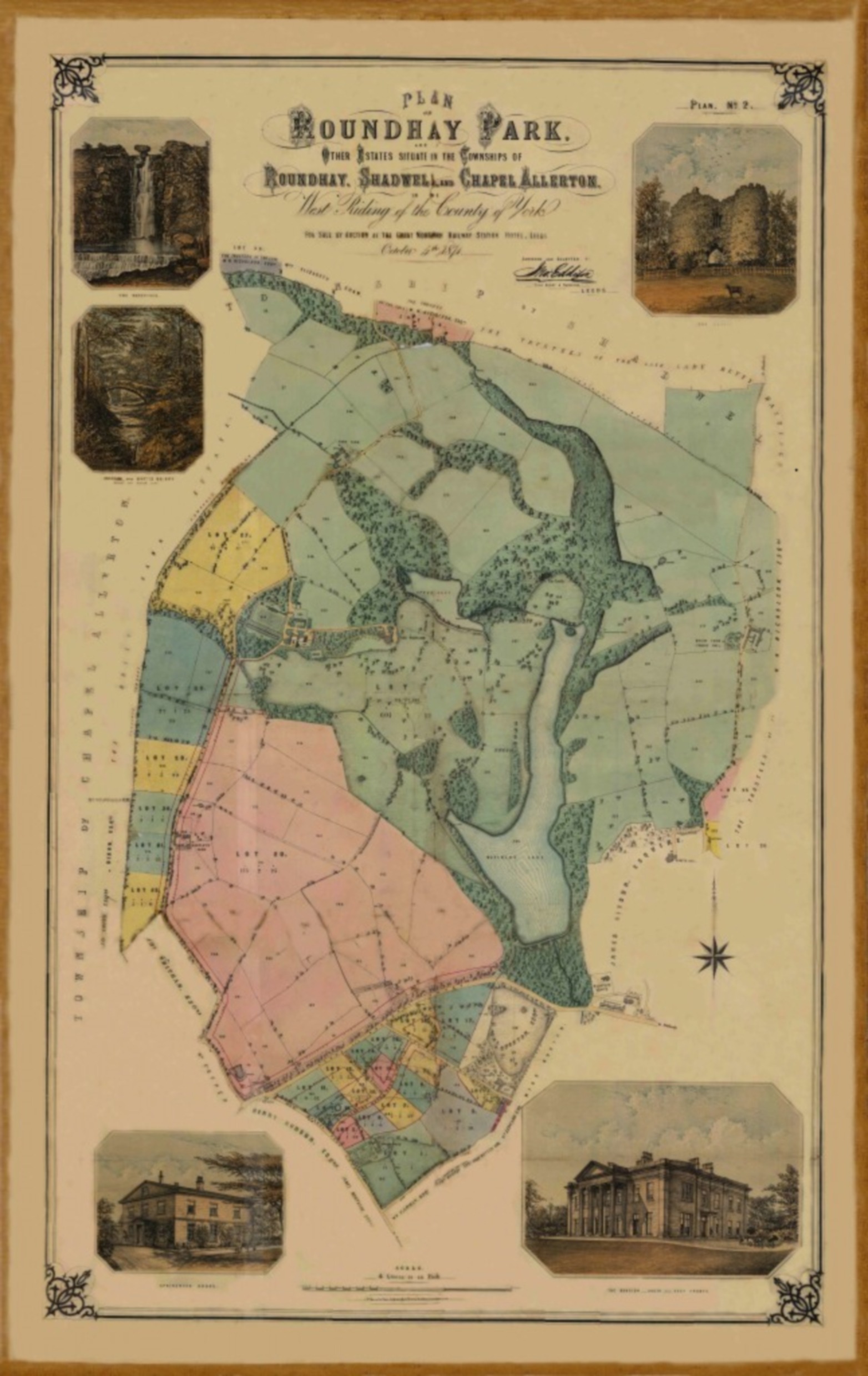
Historic Map
In his book “An Illustrated History of Roundhay Park”, the author, Steven Burt describes how the land containing the Park came to be purchased by John Barran , the Mayor of Leeds in 1871, for the use and benefit of the citizens of the city.
A historic map rediscovered
Roundhay Park’s geology is rich and diverse, featuring different types of rock—some quarried for building stone—and traces of coal deposits from its location on the edge of the Yorkshire coalfield. This 3-mile trail takes approximately 90 minutes to complete and offers a fascinating look at the park’s geological history.
THE sale of roundhay park
To arrange the sale of Roundhay Park, the owner enlisted Messrs Hepper & Sons, Auctioneers, and Jonathon Eddison, Land Agent and Surveyor, to create catalogues and detailed plans. In the 1871 sale catalogue, Roundhay was described as:
“Roundhay, of which this splendid property forms the greater part and its chief ornament, has long been regarded as the most charming suburb of Leeds and presents a magnificent landscape unsullied by the smoke of the Town, broken into hill and dale, adorned with rich Plantations and fine Parks, and studded with Gentlemen’s Seats and Homesteads, which, meeting the eye at every turn, afford an amount of enjoyment seldom associated with so close a proximity to a great commercial centre like Leeds.”
Lot 19 – A GRand Estate
Roundhay Park was listed as “LOT 19”, covering 601 acres, 1 rood, and 12 perches.
While a copy of the original catalogue is held in Leeds Library, the accompanying map was not widely available. That changed thanks to a chance encounter at a FoRP lecture.
At one of FoRP’s lectures, member Stephen Halliday, a director at Adair Paxton Limited, revealed that the company had unearthed the original 1871 auction particulars for Roundhay Park, including the historical map.
This discovery came about when Adair Davy and Paxtons, two of Leeds’ oldest chartered surveying firms, merged. During the office move, the auction documents were found, giving us access to this important piece of history.
Restoring a piece of history
The original map had suffered fold damage and sellotape repairs over the years. However, thanks to modern digital restoration, the map has been repaired and revived as a digital image, preserving its historical value.
Although the lot reference (LOT 19) was lost, the map now looks as impressive as ever, allowing visitors to explore Roundhay Park’s rich history in new detail.
